About The Tromp of RotterdamThe diesel powered freighter Tromp of Rotterdam was sailing for Odense when the ship hit a mine and sank on the 9th December 1946. The mine exploded with such force that the Glyvurnæs, a motorized schooner from the Faeroes, was also damaged even though it was quite some distance away. At first the crew of the schooner thought it was their own ship that had hit a mine. They quickly realized that it was in fact the Tromp that had done so and quickly sailed over to give aid to the distressed ship. They rescued all of the Tromp’s crew, and luckily none or the personnel of either ship were seriously hurt.
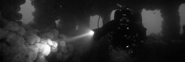
Today the wreck presents a dive full of contrasts. The front part of the wreck is a chaos of sheet metal fragments, pipes, unidentifiable debris and much more. Everything is overgrown with tunicates and porifera as well as large mussels and sea anemones. In amongst the wreckage you might be lucky enough to encounter large fish, but be careful not to disturb anything, as the seabed is very soft, and everything is covered by a layer of sediment, that can quickly ruin the visibility.
If you descend onto the chaotic front part of the wreck, just swim towards the stern over to the more intact part of the ship. Here you will get a much better impression of the wreck. In some places it is possible to look into the wreck, and it is possible to penetrate into the wheelhouse. The railings around the stern are also still in place, but the wreck is slowly breaking up, and pieces of metal the fall off the ship onto the seabed are quickly swallowed up by the soft sediment.
It is very rare to be able to get a good overview of this wreck because of the lack of light at this depth and the imperfect visibility. However the Tromp is a wreck that you will be happy to dive a number of times.
The wreck lies in the shipping lane known as the T-route and the Oslo-Kiel ferry is one of the ships that sail over the wreck. Keep a watchful eye of the large ships, and remember they are sailing much faster than they appear. |